Delta Air Lines is adding some new features to its app to ease the travel experience.
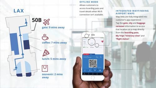
The Fly Delta app, first introduced in 2010, now includes interactive maps for Hartsfield-Jackson International and 14 other airports.
The interactive maps of airports in New York, London, Minneapolis, Detroit, Salt Lake City, Washington D.C., Cincinnati, Seattle, Boston, San Francisco, Orlando, Los Angeles and Tokyo are reached by tapping the airport code or gate number on a boarding pass.
That makes it more intuitive, reduce the need to search for the information and hunt and peck, according to Delta.
There was a key motivation for adding the interactive maps: The challenge of helping customers find their way during a lengthy construction period at Los Angeles International Airport as Delta relocates and upgrades its terminals, requiring the airline to move to a temporary location. In addition to signs in the airport, the interactive maps in the app give passengers another way to get to the right place, according to Rhonda Crawford, Delta's vice president of global distribution and digital strategy.
The idea is that the maps can give travelers an idea of where the nearest Starbucks or restaurant is, for example, or give directions to the next gate or to baggage claim.
Airports are "like cities within cities," Crawford said. More airports' maps are coming later this year.
The new version 4.2 of the app also includes an “offline mode,” giving access to boarding passes and other information even when the device isn’t connected to the Internet or doesn't have a strong connection.
Having access to an offline boarding pass on an app or in a digital wallet app could also help during an outage, when airline systems are down and long lines form for agents to hand-write boarding passes.


