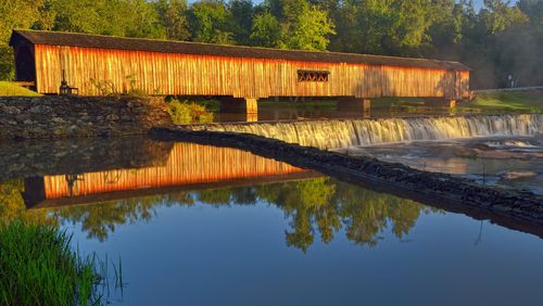
Step aside, Madison County.
That would be the one in Iowa, to be clear, which reportedly inspired Robert James Waller to write 1992’s purple prose-meets-potboiler romance best-selling book, “The Bridges of Madison County.” It boasts six covered bridges, several of which had starring roles in the 1995 film of the same name that featured Meryl Streep and Clint Eastwood, so you’d be forgiven for thinking it’s somehow cornered the market on these rustically beautiful and historically significant structures.
But as the handsome new book “Vanishing Landmarks of Georgia” (John F. Blair Publisher, $19.95) proves, you would be wrong.
“I was traveling around the North Georgia mountains photographing landscapes, and I stumbled across the Poole’s Mill Covered Bridge in Forsyth County,” said Joe Kovarik, who spent some six years working on what became the book. “Then I stumbled across a gristmill and I got so intrigued, I started looking for them.”
By the time he stopped looking (sort of), he’d found and photographed 17 covered bridges and 56 gristmills all over the state — from Barker’s Creek Mill, tucked up in the same part of Rabun Gap where milling has gone on since the mid-1800s and where they now stone-grind grits and cornmeal for local farmers, to the 115-year-old Coheelee Creek Covered Bridge in Early County, which is the southernmost-located original bridge of its kind in the entire United States.
Those fascinating details come courtesy of Kovarik, 70, a retired logistics and operational management professional-turned-avid photographer. Along with gorgeous color photos, each bridge and gristmill gets its own full-page entry that includes a history and description of the site, as well as GPS coordinates and hours of operation so interested readers can plan their visits.
Not every site is open to the public, but unless otherwise noted, all are visible from a public road or park. That’s where Kovarik shot some of the photos from, although in many cases, owners gave him permission to shoot on their property.
At least one of them ground out the welcome mat for him. Just a few miles outside of Cleveland, Ga., lies “Cabin in the Laurel — an 1850s Heritage Farm.” It belongs to Dr. Tom Lott, who’s amassed a collection of about 20 historic log buildings, including a cabin, barn, blacksmith shop — as well as a harder-to-come-by gristmill, which Kovarik says Lott ended up building in 2005 using materials that would age quickly.
“I was roaming around the edges of the property on the highway, and he came by and struck up a conversation with me. He took me up, showed me around and let me take photographs,” Kovarik said of Lott with a chuckle. “(The mill’s) not really historical, but it sure is picturesque!”
Indeed, as the book’s title suggests, gristmills and covered bridges are rapidly disappearing from the Georgia landscape — from as many as 1,300 and 200 respectively in the latter portion of the 19th century. While you can’t stop progress — industrialization and easy availability to steam and gas ultimately proved more efficient than gristmills, which were mostly powered by and located near water — in their heyday, these structures had themselves represented significant progress.
With their pitched roofs and intricate latticework walls, covered bridges now are evocative of romance and secret meetings. Originally, though, they served a highly utilitarian purpose, protecting wooden bridges from wind, rain and other elements that had previously hastened their deterioration. That in turn created key transportation links in and around the state, much as gristmill sites became important gathering spots.
“It became the social center,” Kovarik said of the gristmills, which attracted whole farm families at harvest time and spawned cotton mills, general stores and other new businesses nearby. “The community grew up around the mill.”
Ironically, it took an “outsider” to take note of these vanishing landmarks and give them their due in a book. Kovarik splits his time between Cumming, where his daughter’s family lives, and his own home in Colorado Springs, Colo. He’s busy there now photographing and researching the red rock formation that runs some 150 miles between Boulder and Canon City, Col. But he hasn’t given up the hunt here entirely.
“I don’t have every single gristmill in (the book) yet,” said Kovarik, citing several he couldn’t get owners’ permission to photograph or find any historical information on. “Maybe if there’s a second edition … !”
“Vanishing Landmarks of Georgia” is available at Amazon, BarnesandNoble.com, at select Barnes and Noble bookstores and gift shops in Georgia and directly from the publisher.


